


Contents
Scroll to:
https://doi.org/10.23947/2414-1143-2024-10-2-53-61
Scroll to:
Introduction. The social demand for the development of urban environment as a space of effective interaction of cultures, influencing the quality of life and worldview of modern man, has set the level of complexity of solved problems and determined the priorities in the concept of design of public spaces. Today, there is an emphasis on the ergonomics of navigation systems that have a direct bearing on the level of environmental accessibility. The relevance of research in the field of design of modern visual orientation systems is due to the search for universal means in design engineering that can solve the public demand. The purpose of the article is to provide an analysis of the cultural component of an individual’s socialization, in particular, to identify the factors affecting human orientation in the urban environment in order to determine the priority tools for the design of navigation systems related to the specifics of multicultural society in Southern Russia.
Materials and methods. Theoretical and empirical methods were applied in the research process: collection of material, study, analysis, observation and comparison methods.
Results. The results of the study are the identified relevant methods of orienteering system design such as adaptivemerging, light-shadow method, thematic and technical approaches. The application of these methods in a multicultural society is justified due to a special approach in design: observance of ethno-cultural peculiarities in visual communication and information perception.
Discussion and conclusion. Exploring and incorporating historical context, cultural sensitivity, and the diversity of user needs is key to the design process of visual navigation systems. The practical significance of the identified methods and features of navigational culture of environmental spaces serves as a basis for the design of orienteering systems. The importance of applying the principles of navigation culture in creating a comfortable environment is emphasized.
Kupriyanova E.V., Izyumchenko A.Yu. Navigational Culture of Environmental Spaces. Science Almanac of Black Sea Region Countries. 2024;10(2):53-61. https://doi.org/10.23947/2414-1143-2024-10-2-53-61
Introduction. Locating is a skill and need related to vital human activities and cultural identity. Its orientation in space is done with the help of special equipment or visual navigation systems. Nowadays, traveling is inconceivable without maps, schemes, pointers, especially when it comes to new places of stay. The very term “navigation” (from the Latin. navigo — sailing a ship) originally referred to maritime navigation. In ancient times, people oriented themselves in space by referring to the position of the celestial luminaries, noting the features of the natural landscape, a little later, in the III century. BC. the first references to lighthouses appear and around 2000. B.C. Ancient China already used the first maps of sea coasts and rivers with directions of travel. The look and content of the culture of visual orienteering systems is indebted to the experiences of the past, it is there that we can see what drove the redesign of maps and the development of land-based orienteering systems.
The specifics of multicultural society in the South of Russia have been shaped over the last three centuries. At present, on this cultural basis, there is a growth in the design and construction of architectural environment, assumed new urban planning policy — the principle of polycentric development of southern regions [1]. New urban forms patch the principles of visual orientation and ergonomic fundamentals. The purpose of the article is to provide an analysis of the cultural component of individual socialization, in particular, the factors affecting human orientation in the urban environment to identify the peculiarities of approaches to the design of navigation systems related to the specifics of multicultural society in the South of Russia.
Materials and methods. Theoretical methods helped to reveal the essence of the problem under study: collection of material, study and analysis of literary sources, as well as system-historical analysis of prerequisites for the emergence of visually oriented systems. The basis was the study of historical context and normative methodological documents. An analysis of professional literature has been undertaken — L. Bhaskaran, K.M. Berger, E.V. Ass and analyzed the works of V.N. Badmaeva. Empirical methods of observation and comparison contributed to the identification of regularities and peculiarities of social interactions of representatives of confessions and social groups in the context of the urban environment. Comparative analysis of ergonomic bases used in visual orienteering systems is carried out taking into account the recommendations of M.A. Silkina and V.F. Runge.
Results. On land, the first prerequisites for visual navigation were formed on roadways. Information about the developed transport network in Rome in 300 BC has been preserved, it was represented by signs and mile markers — stone columns along the road [2]. The process of capturing geolocation information has evolved rapidly as the pace of technological advancement has increased. In the fourteenth century in Europe, address plates on architectural objects, signposts within and outside the settlement boundaries are found, and maps are also produced in circulation. In the variety of new forms and typographic pursuits of nineteenth-century information signage, it is possible to identify the evolution of the urban system and the first experience of environmental communication design. Already in the twentieth century, a separate type of information visualization design is rapidly developing to meet the new demands of modernity. It is for this reason that the Bauhaus School of Design made orienteering a discipline in its own right, along with typography and typeface design. The prerequisites for the formation of different types of orienteering systems in different types of spaces in the form to which modern man is accustomed, occurred in the 30s of the 20th century. Such examples can be considered as road interchange and route compilation complexes [3].
The first prototype of the modern map was created by Harry Beck, a London-based designer. He aimed to make the map user-friendly and understandable for the average person, which for the London Underground was a real breakthrough and gained popularity among users due to three basic limitations reflecting the concept of maximum functionality: uniform style for the whole map, route clarity, for each route of movement — a different color. This approach has spurred the redesign of maps and the development of more relevant orienteering systems for humans. In the 1950s and 1960s construction of complex objects is gaining popularity, the urban system and transport interchanges are becoming more and more complex, people are increasingly traveling by private car and tourist points of interest are appearing, which leads to the need for the development of visual orientation. There was a division of the system into address and transportation directions and, among other things, special attention was paid to its aesthetic functions [4].
Recognized as a masterpiece by the professional community, Kevin Lynch’s The Image of the City, written during that period, explores people’s interaction with the city and provides a new understanding of space as a system with its own boundaries, points of intersection, landmarks and its own language. This “language of space” has become a reference point for contemporary designers and architects. In the 70’s, the universal design approach was taking shape in the process of creating accessible environments, and the direction of visual navigation was developing within it. An iconic figure in the world of creative design was architect Ronald L. Mason, who first used the term “universal design”. It addressed the problem of the accessibility of the environment to the general public and the directed formation of a culture of humansystem interaction in public spaces. The main principle of the navigation design was the equality of all population groups. The orienteering system manufacturer took up social monitoring and began looking at consumer subtypes to design a loyal and developing environment. It was during this period that the general principles of design in design were formed:
Modern production of visual-communication systems, includes the creation of pictograms and signs that clearly explain the surrounding space, maps and schemes, pointers that orient a person [5 p. 256]. A visual orientation system solves organization issues: structures the space, contributes to the flow of various processes of life activity, forms the image of space, allows a person to feel comfortable both physically and psychologically. But the aesthetic qualities became part of the functional ones quite recently. The main functional task of visual navigation is the competent management of visitor flows, in specific subject-spatial situations, informing the consumer about the environment: norms and hazards, possible routes of travel and the purpose of location objects. A number of ergonomic factors are taken into account to ensure that the transfer of information is efficient and comfortable:
‒ Anthropometric. The ratio of the parts of the object to the human body and the anatomical plasticity of movement.
‒ Psychological. The object should be subject to the peculiarities of human perception, thinking and psychomotor skills.
‒ Psychophysiological. Correlation of the object with visual, auditory and other human capabilities, providing conditions of visual comfort and orientation in the environment.
‒ Physiological. The facility is designed relative to the physical properties of the person, their strength, speed, biomechanical and energy capabilities.
‒ Hygienic. The facility climate meets the requirements for lighting, humidity, temperature, ventilation system, dust, toxicity, various types of radiation, noise, etc.
Designers use all of these aspects of ergonomics in the design of the visual orientation system, from planning the location of media, to the use of typefaces and color schemes. The working area of the navigation media is the height of the base or walls, the ratio of effective area to space, and the presence of other objects nearby. Navigation has a working distance, this is the distance from which information is best read [6]. The design takes into account the ceiling height and the proportional ratio of effective area to space. For example, in a narrow corridor or stairwells, the carrier should be small in size, to be able to cover the whole of it with the eye.
Text in visual communications is a set of fonts and symbols linked by common design principles. In the coding system, letters are used to convey information about the name of an object and numbers about its quantitative characteristics. An important factor in the design of a visual navigation system, is the recognizability of characters and their readability. Therefore, it is generally accepted that it is better to use sans serif, accent-oriented, and non-decorative fonts. In the world practice designers use such fonts as Helvetica, Univers, Sans, Din, Frutiger when designing visual navigation systems. They all have a Cyrillic headset translation. The first font created for navigation in Russia was PT SANS Caption [6, p. 161]. The general technical design requirements for traffic signs recommend the use of Arial.
Color is an effective tool of communicative design, by means of which information is encoded. Color conveys mood, forms a feeling, affects the emotional and physiological component of perception. Turning to the developments of world designers, it is possible to highlight the ergonomic properties of color and form the techniques of its use in the project. For example, the technique of narrow color recognition. It is built on following the capabilities of the individual. The color palette should be no more than 10‒12 color markers, because the human eye is not able to perceive more shades at the same time. It recognizes the following colors to an excellent degree of accuracy: yellow, orange, red, green, purple and blue. This limitation was a consequence of the physiology of visual perception of color wavelengths. It is worth noting that the yellow-green spectral part is perceived better than the others.
The technique of luminance coding. It draws the designer’s attention to opportunities for emphasis using this quality of color, but it is important to remember that brightness can fatigue the viewer, creating unnecessary tension. If visibility conditions are acceptable, it is recommended that no more than 4 luminance levels be used for coding [7].
In today’s professional community, the rules that guide designers when designing a corporate identity color code are quite popular:
‒ at the very beginning of the design, the target audience and the location of the projected facilities should be determined. This will help to create a coloristic scenario of the stay and track how the user will perceive the color;
‒ in order to achieve the best harmonious interaction of color, it is worth using models of the color wheel, with the help of which it is possible to select color combinations, focusing on color schemes;
‒ the higher the contrast, the better the information can be read. Background and font color contrast should be at least 50‒70 %;
‒ combine colors according to industry standards. For example, for banking, red and yellow colors are considered inappropriate;
‒ it is generally accepted that the placement of white letters on a dark or bright background, subject to contrast, have the ability to be read better than dark fonts on a colored bright background;
‒ more accurate recognition of color contributes to its quantity — a colored background with a white image is perceived as color, and a white background with colored images as “dark on light”. This is especially true for internally illuminated signs.
The creation of navigation systems does not do without pictograms. It is a means of reducing an image to a simple and quick-to-read sign. Its origin also occurred in antiquity with cuneiform and hieroglyphics and modernized with the development of visual communication. Now in a world community of designers there are standard systems of pictograms on which it is possible to be guided at creation of signs it is pictograms ISO, the USA DOT and system of pictograms of designer O. Aicher [3]. At the same time, the experience of the world design community has accumulated enough new creative solutions based on modern approaches and trends in visual language [8].
Speaking about the legal aspect of navigation design, it is worth noting that today in the Russian Federation there is no unified register for all types and directions of visual information environment, that is why some standards, rules and tolerances are determined by the manufacturer independently when producing these products. The national standard “Information signs of the navigation system in tourism”, which are the basic framework in the design of tourist navigation, clarifies the general requirements in the field of tourism. In recent years, a unified standard in the field of medical services has been undergoing expert evaluation and formation, which was preceded by an experimental experience due to the “Order on approval of the Methodological Recommendations for the formation of a navigation system in medical organizations of the Moscow region” [9]. Including defined standards of information transfer for the disabled “Tactilevisual means of information and navigation for the visually impaired”, the navigation project for “Ilyinskaya Hospital” can testify to their application (Fig. 1).
One of the main documents that can be used as a reference for the overall design of the navigation system is the “Methodological Guide for the creation of a system of road signs to cultural heritage sites and other information carriers” approved by the Ministry of Culture of Russia. The manual was published in 2013, and it articulates and clarifies the basic provisions to ensure a functional and safe environment:
‒ informative — providing easy, accessible and fast navigation;
‒ visibility — ensuring quick recognition of information;
‒ uniformity of visual elements is mandatory for the system regardless of the type of information carrier;
‒ aesthetics — the ability of the visual elements of the system to fit seamlessly into the landscape of the area and facilities;
‒ tolerance — conformity of visual elements of the system to the perception of representatives of different nationalities, religious confessions, as well as persons with disabilities;
‒ manufacturability — applied visual elements of the system should be easy to manufacture, install and dismantle, and maintain.
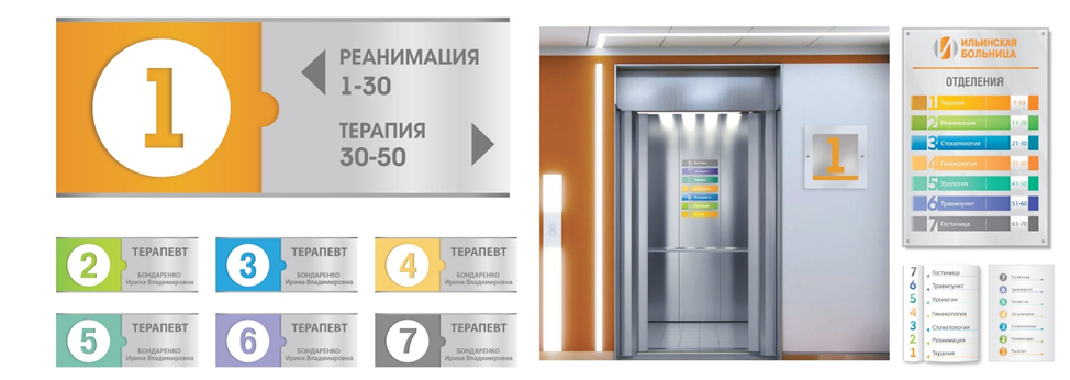
Fig. 1. Ilyinskaya Hospital
The main task of navigation is to be accessible to people from all walks of life. Therefore, when it comes to novelty and the search for creative solutions, it concerns the combination of modern plastic forms and recognizable traditional symbols and signs that have historical and evolutionary signs of the era, integrating the navigation system itself into the environment in the most aesthetic and environmentally friendly way. One of the experimental approaches was the Adaptive Merging method, the essence of which is the smooth integration of landmarks in natural environments — in parks and reserves. It has been welcomed by users for the subject-visual fusion with the living nature of the introduced objects, which delicately mimic and yet remain visible (Fig. 2).
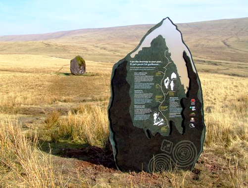
Fig. 2. Navigation in the form of the Maen Lila rock
This method is also used in the urban jungle, selecting natural and synthetic modern materials (Fig. 3, 4).
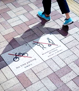
Fig. 3. Navigation on the tile. Lyon Navigation on the tile. Lyon
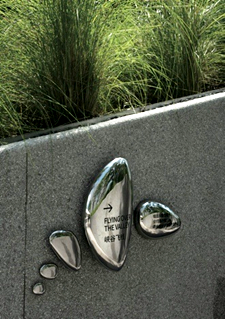
Fig. 4. Landmarks in the form of metal stones Landmarks in the form of metal stones
A further series of examples of experimental navigation, collected by the light-shadow method (Fig. 5). Such an orientation system design requires a special approach in the design of light and shadow fixation in a particular area of the environment. The technique is just gaining popularity, the introduction is more frequent in the non-profit entertainment industry, and in everyday life it is found in shopping malls.
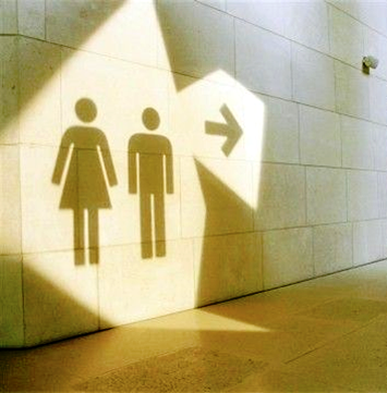
Fig. 5. Light and shadow signage
A favorite method in the organization of play spaces, festivals and cultural public spaces has been the thematic approach, which is characterized by creativity in the choice of materials, forms and installation angles (Fig. 6).
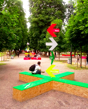
Fig. 6. Thematic navigation
Modern technology brings considerable variety to the creation of an orientation system, both on the technical side and in the choice of materials. The technological approach in the creation of the guide was presented at Astana Expo 2017 in Kazakhstan on the theme “Energy of the Future” (Fig. 7).
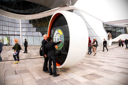
Fig. 7. Travelguide in Kazakhstan
The master plan developed by AS+GG divides the area into four zones, each containing a themed pavilion dedicated to the four elements. The Moscow Planetarium is interesting for its modern approach, which involves the plasticity of the interior space. Navigation is subordinated to the architecture of the ceiling with the help of LED illuminators, while signage contours to the shape of the walls, creating a flowing effect through the same flexible light strip (Fig. 8).
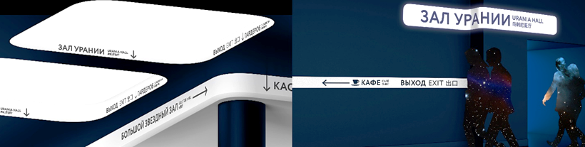
Fig. 8. Moscow Planetarium Moscow Planetarium
Thus, even though the standards base for creating navigation is just emerging, designers are quite convincing in incorporating creative ideas into orientation systems.
The development of social and cultural infrastructure of the city directly affects the quality of life of people. Communicative design besides functional performs the social function of cultural enlightenment and aesthetic education. By influencing personal development, it contributes to the preservation and affirmation of positive human meaning. Competently organized visual navigation, oriented to consumers of a wide spectrum, is able to create an atmosphere of psychological and emotional comfort for a representative of any confession, social group and level of representation if it becomes a projection of deep universal values. The formation of a navigation concept, for example, in the South of Russia requires a certain approach related to the peculiarities of a multicultural society. First of all, it is connected with the geopolitical position of densely populated multinational territories, where ethno-cultural interactions, which have become the foundation of the socio-social structure, are significant.
The identity of the southern region has historically been formed in the conditions of cross-fertilization of cultures of different ethnic groups: Adygeans, Ingush, Kabardins, Karachais, Ossetians, Circassians, Chechens, Kalmyks, Russians, Ukrainians, Cossacks, and displaced peoples: Armenians, Koreans, etc. Interethnic ties are tightly woven in the economic, social and social spheres, and at the same time the conditions of careful attitude to the preservation of ethnic identity are created [10]. Therefore, visual communication of the southern region, inhabited by people with different mentalities and confessional traditions, becomes an integral and significant part of interaction in environmental contexts and at different levels. Within the framework of the programs of the Presidential Fund for Cultural Initiatives, a condition has been put forward that the construction of cities should be carried out through cross-cultural design [11]. Designing visual orientation is at the forefront of this trend, as the meaning of communication in different types of environmental spaces should be intellectually and emotionally perceived by any audience. Key features of cross-cultural projects aimed at technologies of ethnicity saving and development:
‒ communication in different dialects of a language;
‒ differences in working methods and decision-making processes;
‒ differences in cultural backgrounds and values;
‒ respect for cross-cultural differences.
In order for the design of the orientation system to be unambiguously perceivable and correct for representatives of different cultures, it should be taken into account:
‒ ethnocultural symbolism and archetypes in the creation of pictograms;
‒ permissible forms of address in the information block;
‒ features of color-perception and ornamental meanings of cultures.
Discussion and conclusion. The historical and cultural prerequisites for the emergence of navigation and diverse forms of communication were analyzed. It helped to identify the main tools and methods of information transfer, which helped to identify the main vectors of design development of visual orientation systems. Current trends, ergonomic factors, legal frameworks, and common standards laws are described. Examples of realization of creative ideas of designers and actual methods of designing navigation systems are presented. The factors influencing human orientation in the urban environment and related to the specifics of multicultural society in the South of Russia have been identified. These are differences in dialects, in the nature of interpersonal interactions, in cultural peculiarities of behavioral traditions and values.
The project of navigation on the basis of created standards, based on the principles of cross-cultural design, will become viable if, in addition to performing the main functions will contribute to the prevention of complex or conflict situations in a heterogeneous society, aesthetically uniting people of different strata and cultures, building a favorable environment for mutual understanding.
1. Subbotin O.S. Evolyutsiya i spetsifika razvitiya sredy zhiznedeyatelnosti Kubani: XVIII ‒ XX vv = Evolution and specifics of the development of the living environment of Kuban: 18‒20th centuries. Dissertation of Doctor of Architecture. Minsk; 2024 (In Russ.).
2. Ass E.V. Dizayn v kontekste gorodskoy sredy. Nekotoryye teoreticheskiye i tvorcheskiye problemy: Dizayn i gorod = Design in the context of the urban environment. Some theoretical and creative problems: Design and the city. In the book: Trudy VNIITE. Ser. Technical aesthetics. Moscow; Issue 29 (In Russ.).
3. Natsionalnyy standart RF GOST R 57295-2016 = The national standard of the Russian Federation GOST R 57295-2016. Sistemy dizayn-menedzhmenta. Rukovodstvo po dizayn-menedzhmentu v stroitelstve = Design management systems. A guide to design management in construction. URL: https://base.garant.ru/71892374/ (Accessed 15 August 2023) (In Russ.).
4. Berger K.M. Putevodnyye znaki. Dizayn graficheskikh sistem navigatsii = Guiding signs. Design of graphical navigation systems. Moscow: Rip-Holding; 2006 (In Russ.).
5. Bhaskaran L. Anatomiya dizayna: reklama, knigi, gazety, zhurnaly = The anatomy of design: advertising, books, newspapers, magazines. Translated from English. V. Khoros. Moscow: Astrel; 2006. 256 p. (In Russ.).
6. Silkina M.A., Sokolova M.A. Elementy blagoustroystva i navigatsiya v gorodskoy srede = Elements of landscaping and navigation in an urban environment. A study guide. Moscow: Arkhitektura-S; 2016. 161 p. (In Russ.).
7. Runge V.F., Manusevich Yu.P. Ergonomika v dizayne sredy = Ergonomics in the design of the environment. Moscow: Arkhitektura-S; 2009. 211 p. (In Russ.).
8. Miyazaki A. Pictogram and Icon Graphics. PIE Books; 2008.
9. Yakovleva T.V. Metodicheskiye rekomendatsiy po formirovaniyu sistemy navigatsii v meditsinskikh organiza-tsiyakh = Methodological recommendations for the formation of a navigation system in medical organizations. Methodological manual. Moscow; 2019 (In Russ.).
10. Badmaev V.N. Pogranichnost sotsiokulturnogo prostranstva Yuga Rossii = The borderline of the socio-cultural space of the South of Russia. Vestnik VGTU. 2023;15(1):26‒30 (In Russ.).
11. Lugovsky A.F. Kross-kulturnyy aspekt dizayn-deyatelnosti v usloviyakh globalizatsii = The cross-cultural aspect of design activity in the context of globalization. Iskusstvo i kultura. 2020;37(1):48–51 (In Russ.).
Kupriyanova Elena Vladimirovna, Associate Professor of the Department of Design, Don State Technical University (1, Gagarin Sq., Rostov-on-Don, 344000, RF)
Izyumchenko Anastasia Yurievna, Master, Don State Technical University (1, Gagarin Sq., Rostov-on-Don, 344000, RF)
Kupriyanova E.V., Izyumchenko A.Yu. Navigational Culture of Environmental Spaces. Science Almanac of Black Sea Region Countries. 2024;10(2):53-61. https://doi.org/10.23947/2414-1143-2024-10-2-53-61
344000, Rostov-on-Don, Gagarin sqr, 1, building 8, office 411.
Tel/fax: +7 (863) 273-86-63
e-mail: science-almanac@mail.ru